APPENDIX:
SURVEY DATA AND BEACH PROFILE GRAPHS FOR THE REEF BALL™ ARTIFICIAL REEF
SUBMERGED BREAKWATER AT GRAN DOMINICUS BEACH RESORT, NEAR BAYAHIBE, DOMINICAN
REPUBLIC
May 2001
Performed by: Dr. Lee E. Harris, Ph.D., P.E.
Associate Professor of Ocean Engineering & Oceanography
Division of Marine & Environmental Systems
Florida Institute of Technology
Melbourne, FL USA
Performed for: Ing. Miguel Angel Cabral Espinal
EMPACA Ecotourism & Environmental Projects
Santo Domingo, Dominican Republic
Table of Contents.................................................................................................................................1
Beach
Profile Survey Data................................................................................................................... 2
Shoreline
and Sand Volume Changes................................................................................................... 4
Recommended
Modifications and Beach Maintenance......................................................................... 6
Discussion
of the Recommended Modifications and Beach Maintenance............................................... 7
List of Tables and Figures
Table 1. Sand Volume Calculations......................................................................................................... 4
Figure 1. Location of survey profile lines................................................................................................. 2
Figure 2. Survey profiles across breakwaters at gaps............................................................................... 3
Figure 3. Survey profile east of breakwater for Gran
Dominicus Phase 2.................................................. 4
Figure 4. Increased beach with at Gran Dominicus.................................................................................. 5
Figure 5. Project Recommendations........................................................................................................ 7
Beach Profile Survey Data
This Appendix presents the survey data and graphs documenting the existing conditions and recommendations for the Reef Ball™ submerged breakwater constructed offshore of the Gran Dominicus Resort, located on the south Caribbean coast of the Dominican Republic near Bayahibe (east of Santo Domingo and LaRomano). Post storm surveys of the Reef Ball artificial reef submerged breakwater were performed during February 1999 (6 months after project construction and 4 months following the direct hit by Hurricane Georges in September and the large swell waves from Hurricane Mitch in October). The latest survey was performed in April 2001 (26 months after the February 1999 survey and 32 months after project construction).
The aerial photograph in Figure 1 shows the submerged Reef Ball™ breakwater and the locations of the survey profile lines. Figures 2 and 3 show graphs of the survey data comparing the beach profiles in February 1999 and April 2001. The two graphs in Figure 2 clearly show sand accretion, with a 10m shoreline advance at the west end of the project and 13m shoreline advance at the east end of the project. Figure 3 shows the area immediately east of the project, at the site of the proposed Phase 2 of the Gran Dominicus Beach Resort, where very little change in the amount of sand can be seen. Comparisons between these three graphs in Figures 2 and 3 clearly show that the beach has gained a considerable amount of sand, and the shoreline has advanced significantly in the project area, but has remained stable to slightly accretionary on the adjacent beaches.
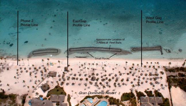
Figure 1. Location of survey profile lines
April 2001 Aerial Photograph of Gran Dominicus - The locations of the survey
profile lines are shown, and the submerged breakwater segments using
three rows of Reef Ball artificial reef units are clearly visible..

Figure 2. Survey profiles across breakwaters at gaps.
Comparison of surveys performed in April 2001 and February 1999.
Figure 3. Survey profile east of breakwater for Gran Dominicus Phase 2.
Comparison of surveys performed in April 2001 and February 1999.
Shoreline and Sand Volume Changes
The survey data from February 1999 and April 2001 were used to compute the shoreline changes and sand volume changes in the project area. The results are shown in Table 1, with the sand volume change per shoreline length computed from the dune seaward to the breakwater (shore parallel distance = 49 meters for west breakwater gap and 44 meters for the east breakwater gap). Figure 4 shows photographs taken at the same times as the surveys, to visually document the beach changes.
Table 1. Sand Volume Calculations
|
Profile Line Designation |
Shoreline Change (meters) |
Sand Volume Change (cubic meters per linear meter of shoreline) |
|
West Gap Profile Line |
+10 m |
+25.65 m3/m |
|
East Gap Profile Line |
+13 m |
+44.25 m3/m |
|
Phase 2 Profile Line |
0 m |
+2.0 m3/m |
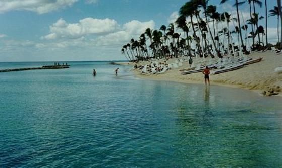
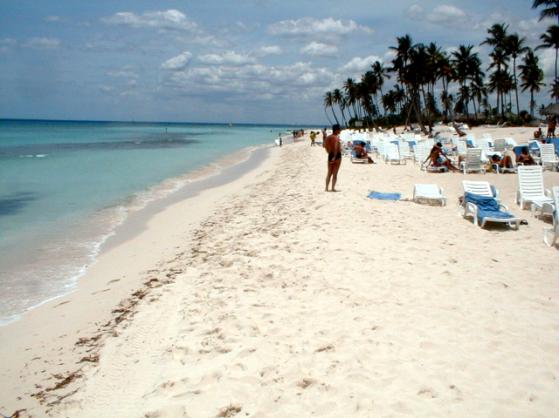
Figure 4. Increased beach with at Gran Dominicus.
February 1999 photograph after the small rocks were added on top of breakwater and sand fill added to the beach (top photo), compared with April 2001 photograph showing large natural accretion (lower photo). The offshore breakwater is clearly visible in each photograph, with the upper photograph showing the small rocks originally placed on top of the breakwater, and the lower photograph shows the small rocks scattered land ward of the Reef Ball breakwater.
The average sand gain in the project area from February 1999 to April 2001 for the two surveyed profile lines in the breakwater area is 34.95 m3/m. Using that average gain over a shoreline length of 250 meters results in an overall volume gain of 8,740 cubic meters of sand. That is the equivalent of an average gain in beach elevation of 75 centimeters over the 250 meter long by an average of 46.5 meter wide beach area. Using the Phase 2 area as comparison, the gain of 2.0 m3/m over 250 meters of shoreline length results in a gain of 500 cubic meters of sand, which is the equivalent of an average gain in beach elevation of 4.3 centimeters over the 250 meter long by an average of 46.5 meter wide beach area. These data show that the gain in sand volume was almost 20 times greater in the project area than on the adjacent beaches.
Recommended Modifications and Beach Maintenance
The data show that the Reef Ball submerged breakwater is greatly assisting with the stabilization and build-up of the beach at the Gran Dominicus Resort. However there are two problems:
1. insufficient swimming area between the shoreline and the breakwater, and
2. small rocks and sea urchins hazardous in the swimming area between the shoreline and the breakwater.
There are a number of solutions to these problems, including:
1. moving the Reef Ball submerged breakwater further seaward,
2. removing the smaller rocks landward of the existing Reef Ball submerged breakwater,
3. performing beach maintenance, including the removal of sand from the beach area.
The first solution would be quite expensive, and is not recommended due to the satisfactory performance of the existing breakwater. In addition to the costs in moving the Reef Ball units further seaward, they would be in deeper water so that they would be less effective for wave attenuation. Therefore the installation of the Reef Balls would have to be done on bases to raise their height, and additional breakwater width would also be required due to the larger waves occurring further offshore.
Both solutions 2 and 3 are highly recommended in order to maintain sufficient swimming area between the shoreline and the breakwater. Solution 1, the removal of the smaller rocks, will immediately increase the swimming area, with the width increased from 15 meters to 23 meters at the west end of the project area (a 53% increase) and the width at the east end of the project area would be increased from 6 meters to 13 meters a (a 217% increase). The removal of the smaller rocks also will result in the removal of the sea urchins that are living on and in the rocks.
Solution 3, beach maintenance would require Gran Dominicus to monitor the beach area and remove sand when the shoreline advances too far seaward. This sand can be stockpiled for later use (as has been done already), or used for beach fill for Phase 2. Figure 5 shows both Solutions 2 and 3 for the Profile Line at the East Breakwater Gap. At this location, there now are only 6m of width available for the swimming area between the shoreline and the breakwater. The removal of rocks increases this width to 13m, and beach maintenance would increase the width of the swimming area to 20 meters. This provides adequate swimming area without the need to move the breakwater further seaward. For the Profile Line at the West Breakwater Gap, the rock removal results in a swimming area width of 23 meters, so that no beach maintenance is required at the west end of the project at this time.
Figure 5. Project Recommendations.
Discussion of the Recommended Modifications and Beach Maintenance
The removal of the smaller rocks landward of the breakwater will not substantially reduce the effectiveness of the breakwater. In fact, a slight reduction in breakwater effectiveness may assist with natural beach maintenance in reducing the sand gain. If increased wave attenuation is required, the preferred option is to add two more rows of Reef Balls immediately seaward of the existing breakwater, as shown in Figure 5. Due to the increase in depth with distance offshore, and also to increase the wave attenuation, the additional two rows of Reef Balls can be elevated using bases into which the Reef Ball units are fastened using underwater concrete. This option can be postponed until it may be needed, with adequate project monitoring performed to allow for proper beach maintenance and any future structural modifications that may be necessary.
The removal of sand from the project beach will not cause any adverse impacts, and the sand can be used to nourish the adjacent beaches, such as the planned Phase 2 development of the Gran Dominicus Resort. Monitoring of the beach should be performed regularly, and when less than 20 meters exists between the Reef Balls and the shoreline, sand can be removed from the beach by mechanical or hydraulic methods. Mechanical methods include equipment such as a front end loader or tractor, or even manual labor with shovels. Hydraulic methods include the use of a hydraulic lift using a pump system, and is recommended as a less intrusive method that can be employed as needed to pump sand onto neighboring beaches.