BEACH STABILIZATION ALTERNATIVES FOR
<UNDISCLOSED
CARRIBEAN ISLAND> <UNDISCLOSED HOTEL> HOTEL
performed by Lee E. Harris, Ph.D., P.E.
Consulting Coastal Engineer
Assoc. Professor of Ocean Engineering
Florida Institute of Technology
Melbourne, Florida 32901 USA
February 2002
This report presents the results of field inspections that were performed in February 2002 to investigate the beach erosion problem at the <UNDISCLOSED HOTEL> Hotel on Seven Mile Beach on <UNDISCLOSED CARRIBEAN ISLAND> Island, and to determine alternatives that can be considered to restore and stabilize the beach at this site.
Field Investigations
Site investigations were performed on February 8 to 10, 2002. This included inspections and photographs of the beach areas at the <UNDISCLOSED HOTEL> Hotel (see Figure 1), and the beach areas to the south and north along <UNDISCLOSED CARRIBEAN ISLAND>’s Seven Mile Beach western shoreline. Historical photographs of the <UNDISCLOSED HOTEL> Hotel shoreline, and beach width measurements taken by the <UNDISCLOSED HOTEL> Hotel staff were reviewed.
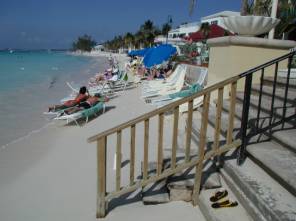
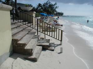
Figure 1. Views North (left) and South (right) from Center of <UNDISCLOSED HOTEL> Resort
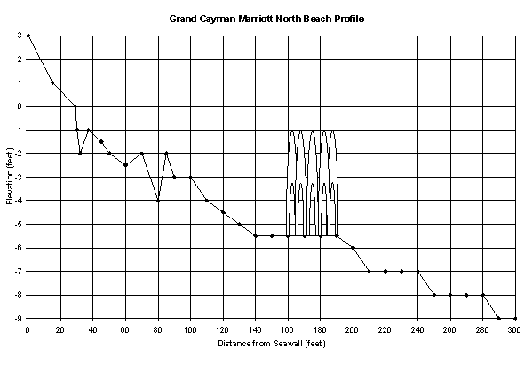
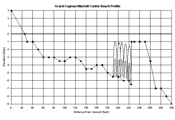
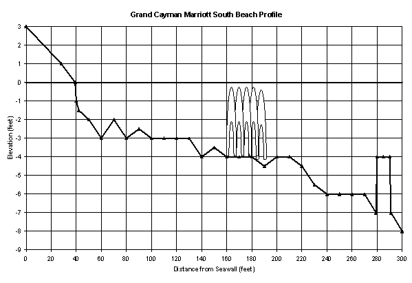
On February 9, 2002 three beach profile lines were surveyed from the beach out to a distance of 300 feet seaward of the seawall to determine the water depths, bottom type, and bathymetry offshore. Underwater inspection of this nearshore area was performed by free diving. The three profile lines were surveyed from the seawall out to a distance of 300 feet offshore, running perpendicular to the shore at the northern, center and southern areas of the property. The measured water depths were adjusted to reflect the beach and sea bottom elevations relative to normal low tide conditions. The measured water depths are shown in the plan view drawing in Figure 2 and cross-sections for the three profile lines are shown in Figure 3.
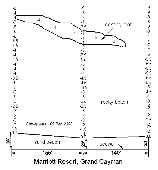
Figure 2. Plan View of Three Surveyed Profile Lines (north is to the right)
The plan view in Figure 2 and cross-sections shown in Figure 3 show the narrow beach depicted in the photographs in Figure 1. The bottom offshore is comprised of sand and rocks, with a natural reef lying approximately 220 feet offshore of the seawall. As the survey data shows, the center part of this reef is high and wide, but it tapers down and narrows to the north and south.
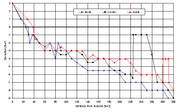
Figure 3. Beach Profile Lines Surveyed 09 February 2002
Beach Erosion Problem
The <UNDISCLOSED HOTEL> Hotel lies at the southern end of Seven Mile Beach. The beaches in this area currently are very narrow, having last been stripped of sand during Hurricane Michelle in November 2001. The beaches to the north become wider as you go north from the <UNDISCLOSED HOTEL> Hotel. To the south, there is a short stretch of sand beach, followed by a rocky shoreline as you approach the Treasure Island Resort. There are some rock groins that were constructed in this area, and the shoreline here curves around to the east. This rocky shoreline to the south and reorientation of the shoreline effectively blocks any potential transport of sand from the south to the <UNDISCLOSED HOTEL>’s beaches.
Therefore the <UNDISCLOSED HOTEL>’s beach area is particularly susceptible to erosion from waves coming from the southwest, due to the lack of sand along the coast to the south. Waves from the southwest, especially during storm events, transport sand to the north. Waves from the northwest tend to transport sand to the south along the Seven Mile Beach area, but this occurs at a much slower rate, and recurring southwest waves over the past few years have prevented the beach from accreting out to the beach width that the <UNDISCLOSED HOTEL> had prior to 1996. Due to the erosion of the beaches along the southern reach of the Seven Mile Beach area, natural sand accretion and return of the beach width to that in the mid 1990’s could take several years, if at all, and any future southwest wave events will further erode the beaches in this area, and slow this natural recovery.
Alternatives for Beach Restoration and Stabilization
Based on the field investigations, alternative methods for restoring the beach and stabilizing the shoreline were developed. For the <UNDISCLOSED HOTEL> Hotel beach, beach restoration and stabilization alternatives include beach renourishment with sand fill, shore perpendicular groins to stabilize this beach sand fill, a shore parallel sill to perch the beach sand fill, and an offshore submerged artificial reef breakwater. These alternatives are discussed in the following sections.
Beach Renourishment with Sand Fill
Beach nourishment with sand fill has been performed in the past by trucking sand in from an upland sand source. Hydraulically pumping sand from offshore to renourish the beach is another method that can be considered for this site. Beach renourishment with sand fill is the most direct way to restore the beach, but with no structures to hold this sand in place, the sand will be easily eroded and redistributed along the shoreline.
Shore Perpendicular Groins
Shore perpendicular groins can be used to hold sand on the beach, preventing it from being washed along the shoreline. By themselves, groins can trap sand on one side, while causing erosion of the beach on the other side. This can be minimized by using short groins, and adding sand to the beach to fill the groins immediately after they are installed. The use of groins as terminal structures to stabilize sand fill placed on the beach at the <UNDISCLOSED HOTEL> by Alternative 1 would increase the longevity of the beach fill. Rock groins can impede pedestrian travel along the beach, so that the use of a design such as sand-filled containers shown in Figure 4 to form the groins should be used to allow pedestrian travel across them.
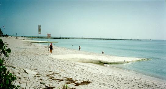
Figure 4. Sand-filled Groins Stabilizing a Florida Beach
Perched Beach
Another method to assist with holding sand on the beach is to install a shore parallel structure seaward of the seawall, and fill the area between this structure and the seawall with fill. The ends of the sill structure must curve back to the seawall at the north and south ends of the property. This shore parallel structure functions as a sill to hold the sand on the beach.. The use of a step-faced sand-filled container such as that shown in Figure 5 allows pedestrian traffic along and up and down the structure when it is exposed.
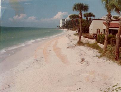
Figure 5. Sand-filled Container with Step-face
Submerged Breakwater
A submerged breakwater reduces the wave action that reaches the beach, thereby assisting to stabilize the shoreline. The use of artificial reef units for a submerged breakwater also provides underwater habitat, enhancing the environment.
Unlike traditional breakwaters that project above the water surface and stop all wave action, submerged breakwaters allow the smaller waves to pass over the structure so that sand transport along the coast is maintained during normal conditions. During large wave events, the larger waves are forced to break on the submerged breakwater, thereby reducing the wave energy reaching the beach from large waves, and reducing the associated beach erosion. The disadvantage of submerged breakwaters is that they become less effective as their depth of submergence increases, so that they are less effective at reducing wave action during elevated water levels due to storm surge.
Artificial Reef Submerged Breakwater Project Design
To stabilize and enhance the beach at the <UNDISCLOSED CARRIBEAN ISLAND> <UNDISCLOSED HOTEL> Resort, an artificial reef submerged breakwater is recommended to reduce the wave action reaching the beach. This will assist in stabilizing the shoreline by reducing the wave action that impacts and erodes the beach, especially when the waves strike and reflect from the vertical seawall. The existing reef offshore of the hotel is only sufficiently wide and high enough to assist with wave attenuation over a short distance, which is where the gap between the two proposed breakwaters is shown.
The recommended design shown in Figure 6 uses 5 rows of Reef BallTM artificial reef units to provide a 30-foot wide submerged breakwater. The 4 to 4.5 feet high artificial breakwater units should be installed in low tide water depths of 4.5 to 5.5 feet, so that the top of the units will be slightly below the lowest normal water level (0.5 to 1.0 feet).
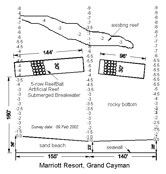
Figure 6. Existing Conditions and Conceptual Design
As presented in Table 1, various sizes and weights of Reef BallTM artificial reef units are available. To obtain the highest heights and individual unit weights possible, the largest Reef BallTM units (Ultra Balls and Reef Balls) fabricated with the maximum volume of concrete for the molds should be used, resulting in each individual Reef BallTM unit weighing approximately 4,000 to 6,000 pounds (2 to 3 tons). Microsilica and other additives are used in the concrete to increase the strength and workability plus decrease the pH of the concrete to that of marine environment.
Table 1. Reef BallTM
Sizes, Weights, Volume & Number of Holes
Style
|
Width |
Height |
Weight |
Concrete |
No.
of |
|
Ultra
Ball |
6 feet |
4.5 feet |
4000-6000
lbs |
1 yard |
29-34 |
|
Reef
Ball |
6 feet |
4 feet |
3000-6000
lbs |
0.75
yard |
29-34 |
|
Pallet
Ball |
4 feet |
3 feet |
1500-2200
lbs |
0.33
yard |
17-24 |
|
Bay
Ball |
3 feet |
2 feet |
375-750
lbs |
0.10
yard |
10-16 |
The sea bottom where the submerged breakwater is proposed consists primarily of barren rock with some patches of sand, so that scour and settlement of the artificial reef units are not a problem. For increased stability of the structure, sleeves for fiberglass rebar will be pre-cast into the Reef BallTM units, with the No. 5 fiberglass rebar driven or drilled into the bottom to provide additional resistance to sliding of the units as they are deployed. If desired, the central cavities of the Reef BallTM units can be filled approximately one-third full with small rocks to provide additional weight and habitat.
Figures 7, 8 and 9 show the cross-sectional views of the artificial reef submerged breakwater at the north, center and south ends of the project area, respectively. Note that the 5 rows of Reef BallTM units are shown in an exaggerated vertical scale in these figures, and the Reef BallTM units shown in the center profile line in Figure 8 is shown as dashed as this area will contain a gap between the two breakwaters, with the natural existing reef providing the wave attenuation in this area.
The field work performed for this report was adequate to determine the viable options for shoreline stabilization, to evaluate the suitability and effectiveness of various alternatives, and to develop conceptual designs. A more accurate and thorough survey of the offshore bathymetry is required to more precisely define the exact location of the breakwater.
 Figure
7. Cross-section at
North Profile Line
Figure
7. Cross-section at
North Profile Line
 Figure
8. Cross-section at
Center Profile Line
Figure
8. Cross-section at
Center Profile Line
 Figure
9. Cross-section at
South Profile Line
Figure
9. Cross-section at
South Profile Line
Conclusions
The <UNDISCLOSED CARRIBEAN ISLAND> <UNDISCLOSED HOTEL> Resort has a beach erosion problem. The existing beach is very narrow, and although it does begin to recover by sand transport into the area from the north, the beach continues to be eroded away by waves coming from the southwest each fall. The staff at the <UNDISCLOSED HOTEL> measures the beach width from the seawall at the north, center and south end of the property every day, with this information providing a good record of beach changes, and should be continued to be collected.
As discussed in this report, there are several alternatives that can be used to stabilize and restore the beach. The most direct approach is to add sand to the beach, and this method has been employed in the past, but the sand is easily eroded away by southwest waves. Structures such as groins or a nearshore sill can be employed to assist in holding the sand in place, but these structural elements can affect the adjacent beaches, and impede the natural transport of sand along the beach.
The recommended and most environmentally friendly option is an offshore submerged breakwater to reduce the wave action reaching the beach. The use of artificial reef units to form a submerged breakwater provides marine habitat, as well as allowing some of the wave action to pass through and over the breakwater so that the natural flow of sand along the beach can continue. The conceptual design of a 5-row Reef BallTM artificial reef submerged breakwater is presented in this report.